Calculating Land Cover Change
-
- 655
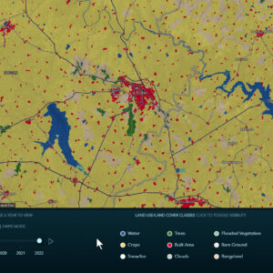
Now it is easy to calculate land cover change with the Sentinel2 Land Cover layers ESRI offers. The Impact Observatory’s deep learning AI land classification model used a massive training dataset of billions of human-labeled image pixels developed by the National Geographic Society. This data is available through the Living Atlas of the World.
Now it is easy to calculate land cover change with the Sentinel2 Land Cover layers ESRI offers. The Impact Observatory’s deep learning AI land classification model used a massive training dataset of billions of human-labeled image pixels developed by the National Geographic Society. This data is available through the Living…
Now it is easy to calculate land cover change with the Sentinel2 Land Cover layers ESRI offers. The Impact Observatory’s deep learning AI land classification model used a massive training dataset of billions of human-labeled image pixels developed by the National Geographic Society. This data is available through the Living…